Well, as you all know, I went with MONSU trips to the Grampians yesterday. I managed to wake up
about 30 minutes before the bus was scheduled to depart and made haste to the pick-up point, which
is a convenient two minutes walk from my place. There were a whole bunch of people already there
and one of the MONSU volunteers handed out the itinerary for the day. The bus arrived from Monash
University in Peninsula with a couple of people already in the bus and we headed to Caulfield to
pick up the rest of the people in the trip. The first stop after that was in Ararat, not Beaufort
as scheduled. We were supposed to stop at Beaufort for a toilet break but that didn’t happen
because Ararat was just a while away. After using the toilets, we passed by Halls Gap and arrived
at Grampians National Park about 3 1/2 hours after we departed.

The Grampians National Park trail marker
We did the Grand Canyon walk, which is a 900 meters walk up rocky terrain. It was quite
strenuous because there was an ascension of 280 meters, which doesn’t sound like much, but it
involves large steps over rocks. I’m having trouble being descriptive today. =D
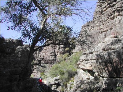
Grand Canyon (The Aussie version)

Steps are mounted to allow navigation through the steeper portions

The walls of the Grand Canyon behind me
There was a strange outcropping of rock at the furthest point of the loop. It was a two rock
formation which looks scalable so I tried going on the first one and pulling myself to the other
rock. Pretty fun, as I needed to support my body weight with my hands at one point.

A little bit of climbing required to get to that vantage point

Me and Jimmy at the Grand Canyon v.Australia.Melbourne
It is interesting to see so many large boulders, I’ve never seen them in this size before. The
loop was supposed to take 30 minutes and we went back to the picnic area for lunch.

Lunch at the Wonderland picnic area
There were several crows in the picnic area and I tried to see how close the crows would come if
I fed them bits of ham. The crows were pretty bold and would snatch up bits of food from in front
of you. There was even some cawing and staring down involved. Heh.

Stand down soldier
Anyway, we were scheduled to depart at 1 pm but there was a group who wasn’t back yet. After a
one hour wait, they finally emerged all sweaty and tired from the path. It seems that one of the
volunteers had taken a group to the Pinnacle Lookout, which is a 4.2 km walk from the picnic area.
Naturally, the rest of the people who were waiting for them wasn’t too pleased at their waywardness
and the volunteer in question got a rather deserved admonishment from the bus driver. Due to the
fact that we’re running late, we had to miss one of the scheduled stops – Jaws of Death. Too bad, I
had wanted to see that one.
Anyway, we headed down to MacKenzie Falls after that. I’ve noticed that we went on the Grand
Canyon Walk instead of going to Boroka Lookout, but that’s just as well coz the Grand Canyon Walk
is pretty nice too. As we arrived at MacKenzie Falls, there was a wallaby wondering wild. A wallaby
is a native animal of Australia which is related to the kangaroos and for all non-scientific
purposes, is a kangaroo, albeit a smaller one. It got spooked pretty easily though and won’t
let me get close to it, even though I tried approaching slowly and crouched down a bit. I had
wanted to put myself into it’s pouch to try and see if I fit or put my arms around it at least.

Don’t hop away…I’m also a wallaby, only slightly bigger and uglier and without fur.
At the MacKenzie Falls trail there was two options – one which went to MacKenzie Falls Lookout
with is a view of the falls from above and one which went to MacKenzie Falls Base which is the view
of the falls from below. Me and Jimmy decided to do both, and started off to the lookout in a very
brisk walk. There was only a couple of people with us as most of them decided to go to the base.
The lookout was pretty high up and since I have a fear of heights, I thought it would be fun to
stand right at the edge.

View of MacKenzie Falls from the top
I scaled the fence and started down the side of the lookout outpost and got myself right to the
edge of the cliff. Dear God in heaven that was scary indeed. I didn’t actually think about it
before I went and done it (I have an impulsive personality) so the fact that there wasn’t anything
that is separating me from a long, long drop to the base of the falls didn’t hit me until I was
right at the edge. Now that I think about it, it would be a waste if I slipped and fell down. I
don’t think people are meant to survive 100 meter falls into rock. There wasn’t anything to stop
you from falling. That was meant to be the fence, which I climbed over to get to the edge. I got
some pretty good photos from up there though.

I won’t be typing this today if I leaned backwards in this picture
Heh. Perhaps next time I would do a cliffhanger from the edge while someone took a photo of me
from below. It’s best not to tempt fate though. 🙂

For reference, here was where I stood in the previous picture. This view is from the
bottom.
Well, after all that, we walked back to the staging point and started to the base of the falls.
There was even more photo opportunities there as you can see MacKenzie Falls up close. It’s
interesting that there is no bridge to go across the river but large stepping stones instead. I
have to say that MacKenzie Falls isn’t much to write home about though. I’ve seen larger
waterfalls in Sarawak. But MacKenzie Falls does have an appealing flow.

MacKenzie Falls close up

Another view of MacKenzie Falls
It’s very relaxing to look at it. I imagine people would enjoy taking some psychedelics while
sitting in front of the falls. Which reminds me, I saw what I think is Gymnopilus
spectabilis growing on a couple of dead tree stumps. I cannot be certain though, for my
knowledge of psychedelic fungi is limited to pictures I saw in a book about magic mushrooms species
in Australia. I did not trust my visual memory enough to pick it, because it would be unfortunate
to accidentally ingest a poisonous strain. Heh.

Me and Jimmy at MacKenzie Falls
If you happen to be visiting MacKenzie Falls, there is some damn good homemade ice cream in the
small booth selling snacks outside. It goes for A$1.80 per cup and has to be heated up in the
microwave for a while to soften it. The owner of the stall was kind enough to give us two spoons
because he said the ice cream is hard enough to break the plastic spoons. Sure enough, I broke my
spoon about halfway through. Heh. It’s very good ice cream though, loved it.
Anyway, after visiting the falls, we headed to our next destination – Zumstein. There was
nothing much to see in Zumstein though. There is supposed to be a lot of kangaroos in that area,
but I didn’t see any. This place is so dismal, I took it upon myself to jump into MacKenzie
River.

Seriously though, I nearly fell down coz the bridge is a suspension bridge and did not like
me swinging over the rail.
That’s about the only interesting thing in Zumstein. MacKenzie River starts here and ends at
MacKenzie Falls. 20 minutes later, we departed again for Ararat, where we had dinner. Ararat is a
pretty nice place, and there was a Target Country there that looks pretty spiffy. Then it was back
to Melbourne and I arrived in Clayton at around 9 pm. The highlight of the day was the Grand Canyon
Walk and MacKenzie Falls. Too bad we couldn’t go to Boroka Lookout because it’s closed from
June-November 2002 for renovations. That can’t be avoided, but the Pinnacle Lookout fiasco which
made all of us miss out on Jaws of Death could. That was poor judgment from one of the volunteers.
He did apologize at the end of the day though, so all is well.





![]()


