Greetings from Melbourne

melb_arrive.jpg

Hello, I’ve arrived in Melbourne yesterday or the day before, I
really can’t gather my scattered thoughts right now, The outdoor doof
was very cold. More about that later, got back yesterday and slept for
more than 24 hours (what a waste) to recover from my non sleep in the
day before I left and the non sleep in the plane. Anyway, I’m going off
now, I’ll do a day by day run through when I reach home, it will be
sporadic posts like this until I get back. Later!

Junaco Park in Sibu (a last hurrah)

junaco.jpg

I went to Junaco Park (Sibu) a couple of days before I came back to
Melbourne – I think it was the evening of the 29th, but those last few
days have been rather hectic and I didn’t have time to write things up
since I was out so often. Oh well, I better do it now in case I get any
more ideas about deleting my precious memories (photos). Anyway, Junaco
Park is this place 30 kilometers away from Sibu which is like a mini
zoo. The entrance fee is only RM 1 per person. There are the usual
suspects like monkeys, horses, birds etc. We went to see the horses
(ponies?) first.

horse.jpg

I had wanted to take a picture of the famed horse phallus, but
unfortunately none of them felt that it was necessary to erect their
organs to their full potential, so all I got was this:

horsepen.jpg

Oh well, next we went to see the monkeys:

monkey.jpg

He’s pretty tame though, contrary to the “Beware – Monkey Bites”
sign on the cage. We handed it grass from outside the cage and he’ll
reach out and take it from us. He has soft hands, which was pretty
interesting. One of my friends thought it was a good idea to try and
trip him with an umbrella (hope no one from RSPCA is reading this) but
the nimble fellow managed to dodge the umbrella every time.
Fascinating. He also loved this bunch of fruits that grows from a tree
to the side of the cage and it was fun to watch him try and eat it
through the cage (coz he couldn’t pull the whole bunch thru the wire
netting).

monfruit.jpg

Next on the itinerary was the sheep (or are those lambs?). Lemme
tell you, those creatures are hella fierce. I wanted to climb over the
fence to hug one of them and pose for a photo, but one of them, which I
assume is the alpha male started making loud baying noises and stamped
his feet to voice his displeasure at my attempts to violate his mate.

sheep.jpg

I reckon he would have bit me had I went into the fence. It probably
wouldn’t have hurt but his head is about the same height as my genitals
so I decided not to risk it, seeing as I was the only son in our family
and protecting the family jewels should be a priority.

Anyway, we also saw some wild boar:

boar.jpg

an eagle or a hawk:

hawk.jpg

big ass fishes (you have to squint a bit for this one):

bigfish.jpg

a peacock (I think):

peacock.jpg

and a porcupine who wanted a staring match with me, despite my obviously superior physical size:

staring.jpg

Anyway, we had wanted to go fishing or go for a ride on one of the
boats, but it was getting dark so we just had a drink at the canteen
and headed home. All in all it was a fun and memorable day. Junaco Park
is pretty big and there is a lot of hilly terrain, so be prepared for a
bit of physical exertion should you go there. Man, writing all this
made me miss Sibu. I can’t wait to go back again in July.

Tasik Biru

tskbiru1.jpg

I went to this lake yesterday but didn’t have time to write it up
until today. It’s this natural (that’s what I heard) lake a couple of
minutes down the road from the Sibu Hospital. There aren’t any signs
pointing to this lake and it seems to be a word of mouth thing. You
have to turn down an unmarked dirt road until you pass a wooden house
and the lake is to the right of the house. It’s the only house down
that dirt road, so you won’t miss it. The lake looks greenish to me
(Tasik Hijau?) but it really is quite pretty and peaceful.

tskbiru2.jpg

There are a lot of interesting formations near the lake, and several
hills made of clay. I went with a couple of friends and we just sat on
a hill overlooking the lake, singing songs as loud as we could. Nice
place to go to if you want to just chill out or something.

tskbiru3.jpg

Rantau Panjang, haircuts and Lan Lan

rp1.jpg

rp2.jpg

rp3.jpg

rp4.jpg

Rantau Panjang. A place 30 minutes from Sibu with a river, a row of
long houses beside the river, driftwood accumulating on the river bank
and erm…and that’s basically it. What is there to see there? Nothing
basically, but there is a wooden bridge leading to a hut where there
are seats and I hear watching the sun set over there is pretty good. I
went there this evening with a couple of friends to just chill out and
talk for a while.

alanhair.jpg

Anyway, I got my haircut tonight at Alan’s Hair Salon (the branch at
Pulau Babi) and it’s a pretty good place actually. They even have a
courtesy cup of tea for you (complete with a top to avoid hair falling
in, no less) and a haircut only comes to RM 10 so that’s pretty good
value for money. After the haircut, we had a late supper at the Sibu
Jaya food court (I didn’t even know there was one there) and then went
to the Sibu airport for a while to use the toilet. The next itinerary
was the hospital where we saw a couple of guys in very bad shape
(visible cuts with congealed blood and all) being stretchered out by an
overworked warden who had to push a guy in a wheelchair with one hand
and pull a guy on a stretcher with another. I also saw a lot of people
setting out rattan mattresses and sleeping on the floors of the
hospital. State funded hospitals are depressing. I had a very bizarre
day though, what a range of places we went to.

Grampians

Well, as you all know, I went with MONSU trips to the Grampians yesterday. I managed to wake up
about 30 minutes before the bus was scheduled to depart and made haste to the pick-up point, which
is a convenient two minutes walk from my place. There were a whole bunch of people already there
and one of the MONSU volunteers handed out the itinerary for the day. The bus arrived from Monash
University in Peninsula with a couple of people already in the bus and we headed to Caulfield to
pick up the rest of the people in the trip. The first stop after that was in Ararat, not Beaufort
as scheduled. We were supposed to stop at Beaufort for a toilet break but that didn’t happen
because Ararat was just a while away. After using the toilets, we passed by Halls Gap and arrived
at Grampians National Park about 3 1/2 hours after we departed.

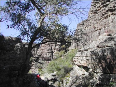
The Grampians National Park trail marker

We did the Grand Canyon walk, which is a 900 meters walk up rocky terrain. It was quite
strenuous because there was an ascension of 280 meters, which doesn’t sound like much, but it
involves large steps over rocks. I’m having trouble being descriptive today. =D

Grand Canyon (The Aussie version)

Steps are mounted to allow navigation through the steeper portions

The walls of the Grand Canyon behind me

There was a strange outcropping of rock at the furthest point of the loop. It was a two rock
formation which looks scalable so I tried going on the first one and pulling myself to the other
rock. Pretty fun, as I needed to support my body weight with my hands at one point.

A little bit of climbing required to get to that vantage point

Me and Jimmy at the Grand Canyon v.Australia.Melbourne

It is interesting to see so many large boulders, I’ve never seen them in this size before. The
loop was supposed to take 30 minutes and we went back to the picnic area for lunch.

Lunch at the Wonderland picnic area

There were several crows in the picnic area and I tried to see how close the crows would come if
I fed them bits of ham. The crows were pretty bold and would snatch up bits of food from in front
of you. There was even some cawing and staring down involved. Heh.

Stand down soldier

Anyway, we were scheduled to depart at 1 pm but there was a group who wasn’t back yet. After a
one hour wait, they finally emerged all sweaty and tired from the path. It seems that one of the
volunteers had taken a group to the Pinnacle Lookout, which is a 4.2 km walk from the picnic area.
Naturally, the rest of the people who were waiting for them wasn’t too pleased at their waywardness
and the volunteer in question got a rather deserved admonishment from the bus driver. Due to the
fact that we’re running late, we had to miss one of the scheduled stops – Jaws of Death. Too bad, I
had wanted to see that one.

Anyway, we headed down to MacKenzie Falls after that. I’ve noticed that we went on the Grand
Canyon Walk instead of going to Boroka Lookout, but that’s just as well coz the Grand Canyon Walk
is pretty nice too. As we arrived at MacKenzie Falls, there was a wallaby wondering wild. A wallaby
is a native animal of Australia which is related to the kangaroos and for all non-scientific
purposes, is a kangaroo, albeit a smaller one. It got spooked pretty easily though and won’t
let me get close to it, even though I tried approaching slowly and crouched down a bit. I had
wanted to put myself into it’s pouch to try and see if I fit or put my arms around it at least.

Don’t hop away…I’m also a wallaby, only slightly bigger and uglier and without fur.

At the MacKenzie Falls trail there was two options – one which went to MacKenzie Falls Lookout
with is a view of the falls from above and one which went to MacKenzie Falls Base which is the view
of the falls from below. Me and Jimmy decided to do both, and started off to the lookout in a very
brisk walk. There was only a couple of people with us as most of them decided to go to the base.
The lookout was pretty high up and since I have a fear of heights, I thought it would be fun to
stand right at the edge.

View of MacKenzie Falls from the top

I scaled the fence and started down the side of the lookout outpost and got myself right to the
edge of the cliff. Dear God in heaven that was scary indeed. I didn’t actually think about it
before I went and done it (I have an impulsive personality) so the fact that there wasn’t anything
that is separating me from a long, long drop to the base of the falls didn’t hit me until I was
right at the edge. Now that I think about it, it would be a waste if I slipped and fell down. I
don’t think people are meant to survive 100 meter falls into rock. There wasn’t anything to stop
you from falling. That was meant to be the fence, which I climbed over to get to the edge. I got
some pretty good photos from up there though.

I won’t be typing this today if I leaned backwards in this picture

Heh. Perhaps next time I would do a cliffhanger from the edge while someone took a photo of me
from below. It’s best not to tempt fate though. πŸ™‚

For reference, here was where I stood in the previous picture. This view is from the
bottom.

Well, after all that, we walked back to the staging point and started to the base of the falls.
There was even more photo opportunities there as you can see MacKenzie Falls up close. It’s
interesting that there is no bridge to go across the river but large stepping stones instead. I
have to say that MacKenzie Falls isn’t much to write home about though. I’ve seen larger
waterfalls in Sarawak. But MacKenzie Falls does have an appealing flow.

MacKenzie Falls close up

Another view of MacKenzie Falls

It’s very relaxing to look at it. I imagine people would enjoy taking some psychedelics while
sitting in front of the falls. Which reminds me, I saw what I think is Gymnopilus
spectabili
s growing on a couple of dead tree stumps. I cannot be certain though, for my
knowledge of psychedelic fungi is limited to pictures I saw in a book about magic mushrooms species
in Australia. I did not trust my visual memory enough to pick it, because it would be unfortunate
to accidentally ingest a poisonous strain. Heh.

Me and Jimmy at MacKenzie Falls

If you happen to be visiting MacKenzie Falls, there is some damn good homemade ice cream in the
small booth selling snacks outside. It goes for A$1.80 per cup and has to be heated up in the
microwave for a while to soften it. The owner of the stall was kind enough to give us two spoons
because he said the ice cream is hard enough to break the plastic spoons. Sure enough, I broke my
spoon about halfway through. Heh. It’s very good ice cream though, loved it.

Anyway, after visiting the falls, we headed to our next destination – Zumstein. There was
nothing much to see in Zumstein though. There is supposed to be a lot of kangaroos in that area,
but I didn’t see any. This place is so dismal, I took it upon myself to jump into MacKenzie
River.

Seriously though, I nearly fell down coz the bridge is a suspension bridge and did not like
me swinging over the rail.

That’s about the only interesting thing in Zumstein. MacKenzie River starts here and ends at
MacKenzie Falls. 20 minutes later, we departed again for Ararat, where we had dinner. Ararat is a
pretty nice place, and there was a Target Country there that looks pretty spiffy. Then it was back
to Melbourne and I arrived in Clayton at around 9 pm. The highlight of the day was the Grand Canyon
Walk and MacKenzie Falls. Too bad we couldn’t go to Boroka Lookout because it’s closed from
June-November 2002 for renovations. That can’t be avoided, but the Pinnacle Lookout fiasco which
made all of us miss out on Jaws of Death could. That was poor judgment from one of the volunteers.
He did apologize at the end of the day though, so all is well.

Mt Buller Postmortem Part II

It has come to my attention that Vivien, my classmate from high school,
has set up a blog. You can visit her
here [blogspot.com]
and someone should tell her that she doesn’t need to do 100 push ups after
just eating 4 cookies. Heh. =D

Anyway, I had a one hour break today and decided to pop into the campus
bookshop with my film developing slip to see if it has been processed. I
was told to check in on Thursday and the price lists states that APS film
takes 6 working days to develop. Well, guess what? They were erring on the
side of caution, because it was already done today! Woo hoo.

The pictures didn’t turn all out well. There were only a couple of
good ones in the bunch. I was pretty impressed with the girth of the
photos though. I took most of them in the panoramic setting so they turned
out really long. It seems that APS film can be developed either in C
(normal size), H (sized like a 16:9 television) or P (panoramic). APS
seems to be a pretty interesting film format. I’ve heard about it before,
but didn’t really know the specifics. If you’re interested, have a read
through the summary of the format

here
[kodak.com].

Well, developing APS film wasn’t as expensive as I thought, but it’s not
cheap either. The processing costs for the 25 exposure roll cost me A$21.50. That comes with 2 index
prints and a Kodak Picture CD though. Added to the cost of the disposable
camera (A$25), that comes to nearly A$50. Tsk tsk…sounds slightly disturbing,
because I’m used to taking pictures with a digicam. Anyway, here are the
pictures from Mt Buller on the day my digicam had a near death experience.

A panoramic shot of me at the bottom of Blue Bullet 1 quad chairlift. This
picture was scanned from the prints.

Carving up the slopes. This picture is taken from the Kodak Picture CD.
The quality of the images in the CD is really bad, you can get much higher
resolutions by scanning in the pictures manually instead of getting a
Picture CD.

This is the friendly manager of YHA in Mt Buller.

Ripping the blue Summit run.

A really grainy shot of the village from the chairlift. A lot of the
pictures turned out badly because there was condensation on the lens of
the camera, and I didn’t realize it. Furthermore, a third of the pictures
have been slightly obstructed by my gloves. The viewfinder of disposables
are not exactly the most accurate things, because I could have sworn that
I see the glove in the viewfinder.

Read Mount Buller Part I.

Mt Buller Postmortem Part I

I just arrived back in Melbourne an hour ago, hurting all over. Heh. It
was a very good weekend, I got a lot of runs in and it was snowing every
day too.

It’s snowing!

I actually only skied 2 out of the 3 days I was there, because I
only arrived at 1:30 pm on the first day and couldn’t justify paying for a
full day lift ticket. I just walked around the village and slopes during
the first day because I could only check into YHA at 5 pm.

This is where I stayed.

I skied the second day and boarded on the third.

Skiing down Bourke Street.

It was pretty punishing
because I was really out of shape. Loved it though. =D I did a couple of
runs down Bourke Street (a green run) on the first day and then went down
the blue Shakey Knees run. I didn’t know it was a blue run until I was
halfway down, and thought…hey, this is pretty steep. I was enjoying
myself so much, I went into an aggressive alpine crouch to pick up speed
(woo hoo adrenaline rush) and wiped out towards the end in an effort to
avoid a stopped skier. Very nice run, but a bit embarrassing on the lift
up. It was a T-bar lift and I unconsciously sat down on the T-bar and
tipped it (I was riding alone) while it was going up an incline. Bourke
Street seems rather anti-climatic after that.

View from Blue Bullet 1 quad chair lift.

I did catch the Quiksilver
GP at night but couldn’t take any photos because it seems that my digicam
does not like snow. I put it into my pants while skiing and forgot to do
up the zip, and as a result, snow got into the pocket and got the digicam
wet. It won’t even start up after that, but after a day of drying out, it
can be started up and the view pictures function is still working and I
can still copy out the pictures, but some buttons seem to be disabled. Doh!
I should have done up my pants zipper but I must have forgotten after
taking it out to snap some photos. (Update – I just tried starting up
my digicam and everything works now. Damn, the Nikon 885 is one tough
motherfucker.
)

Blue Bullet 1 chair lift area.

Anyway, I got a disposable film camera on the second
day before I went boarding. Oh, one funny thing happened today. I went up
to the blue Summit run even though I’m not that good at boarding. I went
for a regular aligned board even though I’m a goofy on a skateboard. I was
carving up the slopes of the summit when the fog rolled in and I
accidentally went down a wrong run. I saw a black diamond flash past and
stopped near the Howqua black run. I had the choice of taking the Kofler’s
T-bar which goes up a steep incline (I do not like heights), taking a long
trek back up the blue Chute run or try to carve black Hawqua. If you’re
not familiar with the color codes, greens are easy runs, blues are for
intermediates and blacks are for experts only. I’ll rather go down black
diamond Hawqua
than take the T-bar up the steep Chute incline coz it will only take one look
down for me to piss my pants. Heh. The end of Hawqua wasn’t really hard
actually, but there are several hazards, including one steep turn that
only has netting between you and a drop down the slopes. I didn’t do too
good though, coz the powdery snow was pretty hard to navigate with my
board. I accidentally did a hard toe edge brake and started losing my
balance. I had the presence of mind to do an ollie to compensate for the
drift but ended up carving my toe edge straight into the power and I must
have flipped 5 meters and ended up face first in the snow. Oh boy…I
couldn’t stand up for a full minute. Heh. I had the wind knocked out of me
and I felt like I cracked a rib. That’s a nasty way to fall, I
reckon…falling ass first is okay, that’s not painful, but going face
first is pretty horrible. Anyway, that’s it for today. I have to wake up
at 7 am tomorrow for my ITPM group meeting. Stay tuned for Part II
tomorrow. I still have a bunch of pictures that’s not up from the
disposable film camera. I’m going to get it developed tomorrow.

Enjoying the fire in the main village.

Read Mount Buller Part II.

Sarikei

I went out at 8 am this morning to get some breakfast with Diana. Picked up Daniel too and headed off to Sugarbun to get something to eat, partly because it’s air-conditioned and partly because we haven’t eaten there in a while.

Me and Diana

Hung around there for an hour before Ah Chan joined us. We had to leave at 10 am though, to meet up with Yi Ching and Justina to go to Sarikei. We went to the city bus terminal to catch the bus, but the buses leaves in 2 hour intervals and we just missed the 10 am bus. We decided to take the express boat to Paradom and catch a bus from there. The bus fare from Paradom to Sarikei is RM 5.40, the most I’ve paid for a bus ticket in Sibu. Heh.

Me and Daniel

An hour later, we were in Sarikei and got some lunch while waiting for Jonas to pick us up.

Lunch at Sarikei

Obligatory picture with Sarikei signboard to show I was there

The pineapple replica in Sarikei town

After lunch, we walked to the tallest building in Sarikei (some government building) because it was air-conditioned. It was really hot today. We walked to Courts Mammoth after that to pretend to try the couches there. Another thinly veiled attempt to enjoy their air-conditioned premises, of course. I saw this interestingly named coffee shop besides Courts Mammoth. It’s named Ma Li Cafe which cracked me up.

Ma Li

If you speak Foochow, the words “ma li” will no doubt elicit chuckles. For those of you who don’t, it sounds like a mild profanity in Foochow. After that, we walked to SMB St Anthony (a high school), who seems to produce several individuals of high caliber.

St Anthony High School

Jonas picked us up from St Anthony’s and we headed to get some ABC special to cool down and headed off to Ngiu Kee to get a large bottle of cold mineral water.

Eating ABC special (an iced dessert)

We went to this new park in Sarikei after that, it’s called the Water Tower Park, if I’m not mistaken. The main feature is an old water tower.

Water Tower Park

The Water Tower

Jonas dropped us off at the government building again after that and we got visitor’s passes to go to the top floor. The top floor is the 10th floor (what did you expect?) and there is nothing much there, except a good view of the river and some exceptionally cool air conditioning.

View of the river with ferry in dock

A friend of Justina’s picked us up after that and took us to Sebangkoi, a nature reserve about 30 minutes away from Sarikei town. Took heaps of pics there and Yi Ching had cramps and was trailing us all through the reserve. =D

Bridge over a waterfall

Rapids

Arrrggghhhhh…the croc got me!!!!!!!!!!!

We headed to Daniel’s uncle’s orchard after that, where I was promptly bitten 1000 times by 1000 mosquitoes.

The orchard

Managed to walk though most of the orchard, which contains ‘landmines’ in the form of holes (some going down as far as 1 feet) which are covered by shrubbery.

Landmine

Tr navigation. I also managed to drive this mini tractor thing, which has no gas pedal, but only a lever to move faster. The gear shift is in between the legs too, and the tractor jittered all the time, which makes an interesting experience.

Mini tractor

We drove Daniel’s uncle’s car to Jakar (har har…sounds like penis in Malay) to get something to eat. Headed back to the orchard after that and hi uncle drove us back to Sibu at around 8:15 pm. Interesting day, but I managed to get mild heat stroke from the obscene heat. Poor Yi Ching was struck by heat stroke too, we’re both sensitive that way. Now where did I put my Poh Chi Kit pills?

all.jpg

From left: Huai Bin (me), Yi Ching, Justina, Daniel

Day trip

I’m heading down to

Sarikei
[sarawaktourism.com] tomorrow with Daniel, Yi Ching and
Justina for Part III of my Rural AdventuresTM. Heh. We’ll be
taking either the express boat or bus there, depending on which one leaves
first. I was also surprised to receive a call from Diana today, who is in
Sibu for only two days. She’ll be leaving tomorrow evening, so I’m going
to grab some breakfast with her tomorrow morning and catch up on things.

Bintangor Day Trip

I headed down to Bintangor today with Daniel for some rojak. Daniel says
that the Bintangor rojak is really good, and sure enough, there were six
other groups of non-Bintangor residents eating rojak there. Anyway, we
took the 2:30 pm express boat out of Sibu wharf. The boat ride took 30
minutes and arrived at Paradom, where we had to catch a bus to Bintangor,
which took 30 minutes as well. There is a large fruit replica right in
Bintangor town, and Daniel says it’s a pau (a kind of large citrus fruit,
don’t know what it’s called in English) while I thought it looked like an
orange. The rojak store had a drink called Bintangor orange juice, which
somewhat supports my theory. I hear Bintangor is famous for it’s oranges
too. Anyway, I found the rojak so good that I bought two bottles of the
rojak sauce to bring back. We had an hour to spare coz the last express
boat leaves at 6 pm from the Paradom wharf, and we’ll be taking the 5:15
pm bus out of Bintangor to catch that boat. Bintangor is not a really big town, and we
managed to cover the whole town on foot in that one hour. Took heaps of
photos too.

The express boat to Paradom.

Paradom Jetty.

96500 Bintangor.

The Bintangor Orange replica.

The old part of Bintangor town.

The new part of Bintangor town.

The non working clock tower in the new part of town.

Old skool barber in front of the football field in Bintangor. Floyd the
barber is cutting the hair of the old man while two people wait for his
services.

I see people like to hang clothes out to dry from their window over here.

The famous rojak stall in Bintangor.

The rojak. Mmm…

Bintangor orange juice.

Got a couple of bottles of rojak sauce to go before we went back.

Related Posts Plugin for WordPress, Blogger...